News
Public safety
Flood evacuation alerts expand in Pemberton, B.C., with more rain in forecast
January 31, 2024 By Chuck Chiang, The Canadian Press
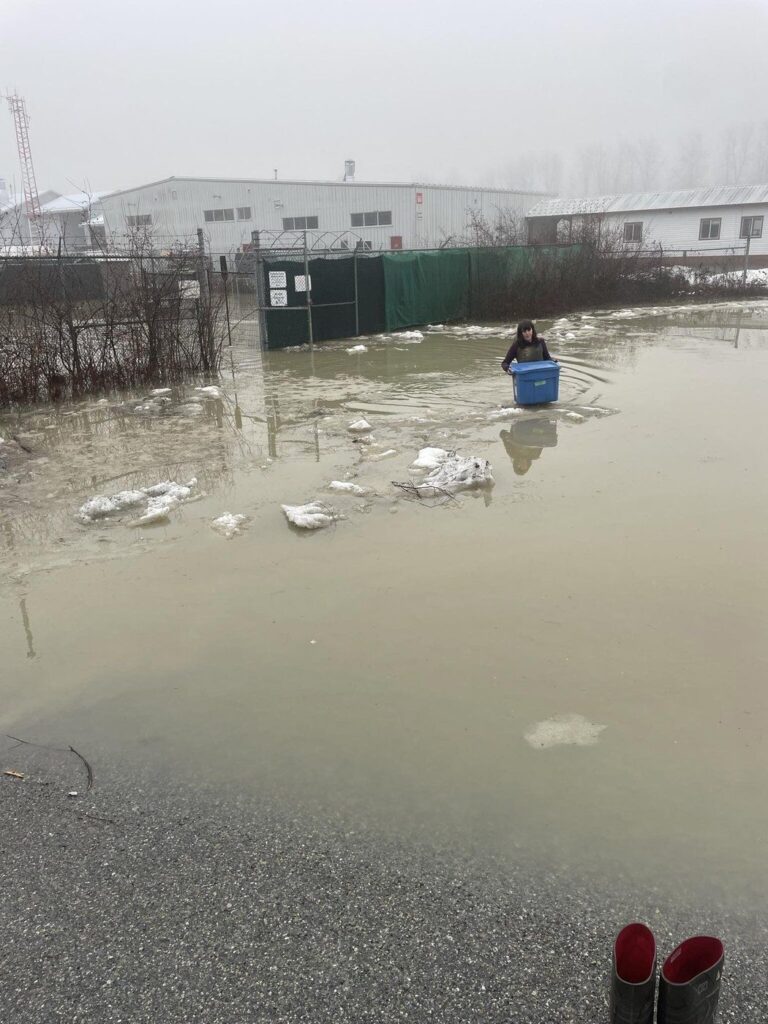 A weather system with unseasonal warmth has melted snow in the mountains and brought drenching rain to B.C.'s South Coast, pushing some rivers over their banks. A Pemberton Animal Wellbeing Society volunteer wades through floodwaters near Pemberton, B.C., in a Tuesday, Jan. 30, 2024, handout photo. THE CANADIAN PRESS/HO-Pemberton Animal Wellbeing Society
 Dusty McKinnon says driving through floodwaters in Pemberton, B.C., reminded him of fording rivers in Costa Rica, as water surged over the hood of his truck.
A weather system with unseasonal warmth has melted snow in the mountains and brought drenching rain to the community 150 kilometres north of Vancouver.
It’s part of a series of atmospheric rivers — moisture-laden streams of warm Pacific air — that have been deluging the province’s South Coast since the weekend, pouring vast amounts of water into raging rivers, sending them over their banks and prompting flood warnings and advisories.
Temperatures have surged over 18 C in parts of B.C.’s Lower Mainland this week.
A bulletin from B.C.’s River Forecaster on Wednesday said rainfall since Friday has ranged from 70 to more than 500 millimetres across the region, while the warmth has added between 75 and 150 millimetres of snowmelt over the last three days.
McKinnon said the water on roads reached the grille of his truck on Tuesday in Pemberton, where six rural properties have been ordered evacuated.
“I have a big truck, and it was little scary because it was pretty deep in one spot that I went through,” he said.
“You better have a snorkel you know, it’s pretty deep out there … I was pushing the water, as you do when you’re driving across a flood scene, and some of it came up over my hood.”
The Squamish-Lillooet Regional District added two Pemberton properties to the list of dozens under evacuation alert on Wednesday, including a mobile home park, with residents told to be ready to leave on short notice.
McKinnon said it’s not unusual for Pemberton to see some flooding, but never this early in the year.
“It happens, but it’s usually later in the year,” he said. “It’s not right in the middle of winter.”
Imogen Lowery, the assistant manager at the Pemberton Animal Wellbeing Society, said staff from neighbouring Blackcomb Helicopters had climbed over the shelter’s fence to rescue five puppies and their mother from rising floodwaters on Tuesday.
“They immediately saw the state of the yard and how quickly the water was rising and they didn’t even think about it, they just jumped in,” she said.
“They’re truly heroes in our eyes.”
Shelter staff had been continuously monitoring the flood risk, and a report at around 3 a.m. Tuesday suggested river levels had stabilized, Lowery said.
But a volunteer arrived at the shelter early that morning to find the dogs had already been rescued from floodwaters that had risen to waist height, she said.
Lowery said the community is “rallying together,” organizing sandbagging and pumps to keep the waters at bay, as Environment Canada warns of another drenching of rain in the region before conditions are expected to ease by this weekend.
“We’re no stranger in this area to extreme weather,” she said. “It’s an incredibly resourceful town.”
The puppies, whose first veterinary visit had been scheduled for the day of the flooding, will be put up for adoption over the next few days, she added.
B.C.’s River Forecast Centre is maintaining flood warnings for the Lillooet, Squamish and Cheakamus rivers, saying flows were expected to rise through to Friday.
A rainfall warning from Environment Canada said the Howe Sound region, including Squamish, would see another 50 millimetres of rain before it tapers off Thursday.
An update from the District of Squamish said some homes in the Northyards neighbourhood had seen “localized flooding,” but river levels were dropping and crews ran pumps Tuesday night in anticipation of the additional rain.
Flood watches are in effect across the rest of the South Coast, including Vancouver Island, while high stream-flow advisories cover the Central and North coasts.
The forecast centre said flows remain elevated in lake-driven systems, including the Sproat, Somass and Cowichan rivers.
BC Hydro spokesman Stephen Watson said the electricity provider had issued a public safety advisory for the Puntledge and Campbell rivers, as well as Elk Falls Canyon on Vancouver Island, warning of high flows of water discharged from dams.
Watson posted videos to social media showing both river systems as raging torrents.
He said peak inflow of water into the Campbell River on Monday reached 1,310 cubic metres per second, enough to fill an Olympic pool in less than two seconds.
“The volume of water that’s coming in is quite massive,” Watson said Wednesday. “Even as a daily average, yesterday we were getting an Olympic-size swimming pool about every 2.5 seconds, 24-seven.”
He added that the Elsie Lake reservoir in central Vancouver Island was at levels not seen in a decade, and dam discharges were necessary to make sure there was capacity for more rain in the forecast.